I wanted to make foods that represented the flavors of Southwestern Native American cooking before contact with the Spanish. This meant recipes without butter, milk, or spices not native to the southwestern region of the US. Corn and beans are known to be a staple of the Southwestern Native American diet, and the recipes I chose (Zuni succotash and Navajo blue bread) are based on those staple items. Here are the recipes:
To make the bread, I needed juniper ash. So, I collected branches of juniper to ash for the Navajo blue bread. I used a Coleman outdoor grill powered by propane and a metal bowl covered in foil to collect the ashes.
At first I tried to burn the juniper branch and shake it into a bowl, but with trial and error, I figured out the best way to do it was to light a small fire in the bowl with some juniper twigs.
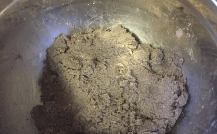
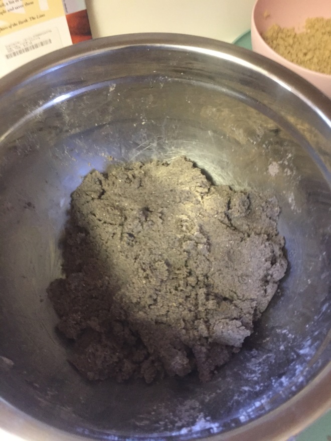
For the recipe, which I doubled, I put four tablespoons of juniper ash into two cups of boiling water and strained the ash water through cheesecloth into four cups of blue cornmeal. The preface to the recipe I used said the ash helped the blue cornmeal keep its color, but sources I found online, such ashttps://navajorecipes.com/corn/juniper-ash/, state that it is used to boost calcium content of the cornmeal. According to the website, blue cornmeal without ash has only 2.4mg of calcium per cup, while blue cornmeal with ash has 802 mg of calcium per cup. That’s a significant nutritional boost, and when you consider the fact that the Navajo did not have milk before Spanish contact, it could be seen as a way to manage a lack of calcium in their diet.
Once I had the blue cornmeal dough, I added some more water until it was an easily moldable consistency and made thin, 3 inch round circles of meal.
I molded each circle right before I placed them in the pan, as the dough was drying out quickly in the bowl and dried out even more if you made the circles ahead of time. I also added a small amount of salt and honey to the dough.
The recipe called for each piece of bread to be cooked ten minutes per side, but even at the lowest heat that was entirely too long. I judged whether they were done by a slight browning in color on either side, kind of like pancakes. As I would put two down in the pan, I would make two more and put those in, then flip the first ones and continue by making two more. This process gave me an even cooking time for all the cakes.
I dipped the finished cakes quickly in salt water when they were finished, and according to the recipe that is the traditional Navajo way to eat them. On a side note, they were also great with butter and dipped in stews or sauces.
For the Zuni succotash, I used pine nuts to make the pinyon nut or sunflower meal the recipe called for. I put the pine nuts in a plastic bag, then a paper bag over that, and pounded them into a meal with a mallet. I would recommend using a mortar and pestle (which we didn’t have), which is not only closer to the traditional way of making nut meal, it is also easier. The recipe did not specify how much nut meal was to be used, so I just used one bag of pine nuts.
While making the pine nut meal, I also soaked dried pinto beans for an hour and brought them to a boil. I would recommend soaking the beans overnight ahead of time, because the beans took longer than anything else to cook, and the texture of the beans probably would have been better.
In the pot with the beans, I cut the kernels off of four ears of yellow corn (substituted for Native American green corn), around 1 cup of ground beef (substituted for venison) and the pine nut meal. I boiled the Zuni succotash all together for about an hour, and added some salt to season it.
I had a fun time making these recipes and they turned out great. It was especially interesting to make the juniper ash, as I had never seen ash used in food before.
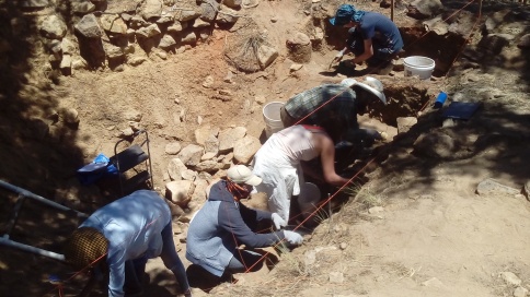
Fire in the Jemez Mountains of New Mexico is essential to the health of its forests and archaeology. To protect and preserve archaeological or cultural sites from damage from the recent, larger scale and intensity fires, requires safe planning. The type of effort that goes into protecting archaeological sites involves creating a plan to reduce fire or erosion hazards that can damage the sites. Using certain fire management methods, the protection of cultural sites increases, and the forest’s landscape and diversity of wildlife resurges.
Photo near the Jemez Mountian Trail area.
Recently, one of New Mexico’s most destructive fires, the Las Conchas fire in June of 2011, raged through 156,000 acres of forest in the Jemez Mountains and destroyed dozens of homes and buildings. The fire reached Bandelier National Monument, near Los Alamos, New Mexico, and burned approximately 1,100 cultural sites that were inhabited between A. D. 1100-1550 by ancestors of many Pueblo groups. In response to the fire, the National Monument and the Forest Service mobilized the Burned Area Emergency Response (BAER). Their job is to combat a wildfire’s after effects in relation to park safety, preserving cultural sites, and to provide post-fire community assistance.
Field house treated by site thinning and placements of erosion controls on a mesa top in the Jemez Mountains.
The effects of fire on archaeology can do irreparable damage to artifacts and the sites themselves which can hinder future research or public visitation and education. To stop potential fire damage, the Forest Service employs methods such as site thinning, prescribed burning (burning sections of forest to limit the spread of wildfires), and erosion controls. Trained archaeologists can assess an archaeological site for fire damage by looking at the site itself for fractured building stone or any artifacts like discolored ceramics. Building from the assessment, careful planning allows for prescribed burns to ensure safety and to prevent the fire from becoming out of control. In conjunction with prescribed burns, site thinning reduces the amount of fuel wood in an area susceptible to fire and prevents the trees from falling on sites or uprooting the archaeology as well as stops the fire from burning for thousands of hours on fragile sites. As a bonus, using cut-down trees allows for the control of erosion and helps with soil retention by laying them against or across erosional elements. Sites treated with these methods show resilience to long burning fires and limited erosion.
The aim of the Santa Fe National Forest has been to restore the landscape to pre-industrial conditions. To do so, employing safe burning methods is key when there are cultural sites present. It is all an effort to have the forest and its cultural sites become resilient to wildfires which, in turn, increase wildlife diversity and improve resource quality. Combined, all aspects of fire management in New Mexico are important to a forest’s ecosystem and preserving cultural context.
The purpose of archaeological research should be twofold- to use archaeological techniques and theory to uncover information about past human groups, and to convey that information to the interested public. Making the results of archaeological research inaccessible through paywalls, dense, jargon-filled writing, or even by simply not compiling and publishing the results of archaeological projects, [such as has occurred at Chetro Ketl in Chaco Canyon (“Chaco Sites” 2019)] negates the main point of conducting archaeological research in the first place. However, the vast majority of archaeological research remains inaccessible to non- professional archaeologists.
There is a pervasive, and not entirely undeserved, perception throughout the Southwestern United States that archaeologists are little better than pot hunters- sweeping in, removing all of the interesting artifacts, and sequestering them away in inaccessible museum collections, leaving the landscape bare, stripped of its history. This view is partially due to the often destructive and problematic historic (and sometimes not so historic) archaeological projects that have been conducted in the American Southwest, coupled with a lack of outreach on the part of current Southwestern archaeologists concerning the newer, less destructive approaches to archaeology that have begun to be broadly implemented. Archaeologists have been lax in their outreach for several reasons.
First is institutional: most archaeological research is conducted though academic or CRM channels, resulting in work that is not targeted towards the general public or descendant communities. Academic work is typically published in journals that require subscriptions to access and CRM “grey” literature is often not made accessible to groups not involved with the project. The second is more personal. Archaeologists can be more interested in conducting field work than analyzing and publishing the results of the work, and after writing for the required academic channels may not have time to or be interested in reconfiguring their work for a popular audience. And finally, archaeological research in the Southwest often has cultural and political implications, ranging from disturbance of sites of spiritual and cultural importance to descendant communities to land ownership and water rights. Archaeologists may limit the extent of their publications to avoid inflaming political tensions.
Fortunately, there has been a noticeable shift in attitudes among professional archaeologists over the past 10 years, with public outreach becoming more valued and practiced. This shift is encouraging but it will take a great deal more time and effort on the part of professional archaeologists to both change institutional attitudes towards public outreach and to connect with skeptical non-archaeologists, non-archaeological members of descendant communities, and other groups who have concerns about or who have been negatively impacted by archaeological research.
After excavation is completed for a project, the archaeologist’s work is not over. Those conducting the research still have to decide how to leave the site. Common solutions (often called site treatments) after digging include backfilling—the practice of covering the entire site or feature—or leaving the site open in hopes that it will be respectfully viewed by the public. Both options come with significant costs and benefits, which means this step of the process can be heavily debated by archaeologists.
Oddly, archaeologists who are busy arguing with their colleagues about whether or not to fill a site often forget the wishes of the descendants of the communities who created them. We can see evidence of archaeologists doing this regularly. For instance, at the Aztec Ruins in northern New Mexico, archaeologists recreated a great kiva—a structure that remains sacred to Pueblo communities in the Southwest—not only incorrectly, but against the wishes of many who could trace their ancestry back to the site (1).
Reconstructed Great Kiva at Aztec uses evidence of construction techniques found at the site and during excavation, but then also adds contemporary interpretations for what monumental architecture should look like. Photo by Lewis Borck.
The focus was incorrectly placed on creating a space fit for modern architectural senses, such as increasing the height of the kiva roof and creating windows, instead of on the intentions of the former inhabitants who choose to leave the site to naturally return to the earth. As a young, white cis-woman studying anthropology and archaeology, I try to remember that my perspective is influenced by my history and place in society. Broader, inclusive conversations can help create better solutions and recreations.
Each site in the American Southwest must be looked at individually, weighing the risks of forgoing preservation through in-filling and the benefits that could be gained from the public being permitted to view the heritage site. Sometimes, the risk of sites being more harshly subjected to degrading factors due to their increased accessibility is outweighed by the need to use these cultural resources to educate the public. In these cases, if the non-Native communities that surround the open sites, who work with them, who visit them, and who are not aware of their significance are shown how important these places are, we hope they will maintain the sites as stewards along with the members of the descendant groups.
Any interaction that archaeologists have with a historical site, feature, or artifact that disturbs its context is destructive. Archaeologists backfill to avoid future destruction to buildings and ancient houses. When archaeologists choose to backfill a site, it is often because they believe that future archaeologists could come back to work on it and gain new information from the parts of the site that remain in context. It was only recently that archaeologists decided that leaving all excavated sites open may not be the best way to preserve both the sites themselves and the relationship with surrounding indigenous communities. When an archaeologist chooses to leave a site open, the fragile artifacts and features are left exposed to wind, rain, fire, and further destruction at the hands of humans. This can be seen at the Gallina site we are working on in the Llaves valley where of the two unit houses that share a wall, only one was backfilled after excavation by the archaeologist. The unit house that was backfilled shows much better preservation of the plaster walls, adobe wing walls, and adobe hearth.
Backfilled structure with masonry walls and interior plaster still intact.
Ancient house left open after archaeological excavations in the 1970s. Structure is heavily damaged by erosional activity. Wall footings are intact, but most interior dirt/adobe features have eroded into undifferentiated adobe “melt”.
Yet, when sites are left open the exposure to the elements can also come with the potential of inspiring people to learn from and protect our human heritage. Some sites, like Nogales Cliff House are located in places that have not experienced the gradual deposition of soil, but are also better protected from the weather. When archaeologists came upon sites like the Nogales Cliff House over a hundred years ago, many were in a similar condition to how they appear today (although Nogales has been heavily eroded after excavations without backfill in one area open to the wind and rain).
Nogales Cliff House: One of the few cliff houses in the Gallina region. Inhabited during the 1200s A.D.
Could there already be enough sites left naturally and artificially exposed to serve the purpose of motivating more to learn about our past? Until more sites are discovered and excavated, it is impossible to say. But, I sure hope that there’s still more to be found to shape our view of the past. However, the desire to respect the choice of the former inhabitants to leave their sites as they were hundreds of years ago, the hope for new, less destructive technology, and the fact that covering a site means that the area on top can be used for other things—like ranching—highlights the importance of backfilling.
(1) These decisions are now openly discussed with visitors at Aztec.
Have you ever tried putting together a complex jigsaw puzzle? You eventually find one piece that doesn’t fit anyplace, put it aside, and work on easier parts of the puzzle, forgetting about that piece. Finally, we fit, what is now, the final piece. Cultural puzzles can follow the same pattern. With the puzzle we call the Ancestral Puebloans, some pieces fit our view of the culture, and some don’t. We understand the pieces known as Chaco Canyon and Mesa Verde, the most well-known Southwestern ancestral sites, and we generally see how Salmon Ruins, and Aztec fit. Other pieces stymie us, and, like the puzzle, we put these aside until we can see where they fit, or, we put the piece in places we think fit. Gallina (pronounced guy-ee-na) is like that. The Gallina Phase contributes to our understanding of the culture as a whole, but is researched by only a handful of Southwest archaeologists, and has been treated, in many ways, as the piece Southwestern archaeologists couldn’t fit into the overall puzzle.
Some of our pieces of American Southwest archaeology may be missing or jammed into the wrong places. Image from Patterns of Resistance (Borck 2012).
The Gallina Phase lasted from AD 1100-1300, 50 years less than the United States has been a country. Archaeological work presents a convoluted picture of the period, with Frank Hibben, who did some of the first serious work in the region, painting a picture of violence that was never ending, and other archaeologists describing the period as a “backwater” or “ordinary, yet distinct,”[1] leaving a wide variety of interpretations. Oral traditions tell us that around AD 1100, things were changing in the Puebloan world. Chaco Canyon was descending into collapse, its people migrating to the Mesa Verde area. Mesa Verde society was changing, becoming more hierarchical, with fewer people controlling parts of the society. To avoid this control, some archaeologists construct a model of residents leaving the Four Corners area, in rebellion, migrating to the Gallina Region, developing a counter-culture to the hierarchy in the Four Corners. Thus, we can determine that the people of the Gallina Phase; (1) Migrated away from areas offering a new, emerging Puebloan lifestyle, (2) Developed dwellings, tools, and pottery different from contemporary Puebloan types, and (3) Sustained this lifestyle for a significant period of time while the remainder of the Puebloan world was undergoing their own societal changes. This writing will examine the differences in Gallina structures, an area of distinct differences from contemporary Puebloan life.
Puebloan structures from about 0 AD through 1300 AD change from small one-family pit houses around AD 200-400, to monumental Great Houses starting in the AD 800s, and the cliff dwellings of Mesa Verde AD 925-1125[2]. While Chacoan and Mesa Verde society built large, apartment building-like dwellings, the Gallina structures, built at similar times, may be seen as throwbacks to pit houses built before AD 700 in regions that switched to these large apartment like structures, and in another way, a new development in construction with “unit houses.” During AD 200-400 (Basketmaker II) pit houses[3] were perhaps five meters wide, three meters deep, generally circular, with a packed dirt floor and an interior fireplace, with deflector. During the Pueblo I Period structure design morphs from single-dwelling pit houses to multi-room communal dwellings. This “Pueblo” style remains the stable form of Puebloan architecture into the contact era in the 1500s.
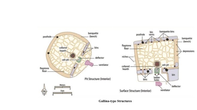
However, Gallina communities break with Puebloan architecture, returning to the pit house style common before AD 700, and constructing single-dwelling surface houses; in both cases, modifying and enlarging these designs, as well as incorporating pit house features into the single room surface structures. They also stop building kivas and incorporate religious architectural elements of kivas into all of their homes. Combined, these demonstrate a greater investment in the house than we see with other structures in Puebloan areas. Gallina pit and unit houses are as much as seven to ten meters wide, with interior fireplaces, flagstone floors, and plastered walls, sometimes incorporating wall motifs, possibly indicating the use of the home as a ritual center with individual families, not a hierarchical group, controlling ceremonies[4].
Borck, Lewis, and J. Michael Bremer, “An Introduction to Gallina Archaeology,” Archaeology Southwest Magazine, vol. 29, #1, page 8, Winter 2015. Figure by Catherine Gilman.
Adobe benches with storage bins and a deflector in front of the fireplace, between it and the ventilator, are expansions from the earlier pit house designs. The unit houses in particular are fascinating structures, seemingly modeling pit house architecture, something only seen in the Gallina region. These are square or rectangular adobe and stone structures with features similar to those found in the pit houses; plastered walls, interior fireplace, deflectors, and ventilators, along with possibly ritual murals on some of the walls. Both the pit houses and the above ground structures are massive in size and scope, and, in the words of Dr. Lewis Borck, “overbuilt” for a single family.[5] What we do not see in the Gallina area is the Pueblo design, multi-room, apartment buildings, which were common elsewhere, nor do we see dense populations in small regions like Chaco, Mesa Verde, or Aztec. Concentrated villages are found in areas of the Gallina region, but consist of clusters of single-family dwellings, one to four pit houses, unit houses, or a combination, within an easy 10 minute walk of each other, not the major villages of other Puebloan areas.
Were architectural changes limited, we could possibly ignore them. However, there are over 2300 of these buildings in a 2,000 km2 area; far too many houses to pass off as a fluke. Also, architectural style changes are only one of a number of modifications seen during the Gallina Phase, including differences in tools and pottery. So where does the Gallina piece of the puzzle fit? Perhaps they simply wanted a less constrained way of life, keeping their individual beliefs intact. One of the original counter culture people of the Americas, the original hippies.[6, 7] Regardless of their reasons, ultimately, their distinct way of life faded into conformity as things they rebelled against faded into history. Around AD 1300, with the excesses of Mesa Verde and the great Chacoan experiment gone, the Gallina people likely migrated south and east, probably settling in the Rio Grande and Rio Chama regions of New Mexico, leaving their structures and artifacts as their history. There lives in the Gallina highlands demonstrate that this was not a marginal area, but a thriving part of Pueblo and local indigenous history, separated, by choice, from the more mainstream Mesa Verde-type societies. While not fully comprehending the reasons for their lifestyle we must admit the Gallina people were 200 years ahead of their neighbors in the Mesa Verde region in rejecting hierarchy. [7]
[1] Bremer, J. Michael, “Ordinary, Yet Distinct: The Gallina Appeal,” Archaeology Southwest Magazine, vol. 29, #1, page 3-4, Winter 2015
[2] Cordell, Linda S. and Maxine E. McBrinn, Archaeology of the Southwest, 3d Ed, pg. 74, Routledge, Taylor and Francis Group, NY,2012.
[4] Borck, Lewis, and J. Michael Bremer, “An Introduction to Gallina Archaeology,” Archaeology Southwest Magazine, vol. 29, #1, page 8, Winter 2015. Figure by Catherine Gilman.
[5] Conversations with Dr. Borck during the period 26 May – 6 July 2019.
[6] Borck, Lewis, and Erik Simpson. “Identity Is an Infinite Now: Being Instead of Becoming Gallina.” KIVA: Journal of Southwestern Anthropology and History 83.4 (2017): 471–493. Web.
[7] Borck, Lewis. “Sophisticated Rebels: Meaning Maps and Settlement Structure as Evidence for a Social Movement in the Gallina Region of the North American Southwest.” In Life Beyond the Boundaries: Constructing Identity in Edge Regions of the North American Southwest, edited by Karen G. Harry and Sarah Herr, pp. 88–121. (2018)
Adapted from the SAA K-12 Activities and Resources on Context
Audience: Grade 3; groups of 4 to 5
Duration ~ 45 – 60 mins
Learning objectives: To learn the importance of artifact preservation and context. Build logical thinking skills and teamwork.
Materials: Index cards ( 30)
Color marker or crayon
Poster Board
Key terms:
Archaeology / Archaeologist
Artifact
Context
Set up:
Create sets of artifact cards for 5 locations. Using one card for each artifact, write or affix a picture. (Ex. A group for a dentist office would have five cards with Stethoscope, Disposable gloves, Blood pressure cuff, Eye chart, Exam table)
On the back of each card make a small color mark for each group. (Ex. Dentist office artifacts = blue line)
On the poster board create a polygon for each color
Shuffle cards
Introduction discussion: Discuss what archaeology is and what we can learn from it.
Instructions:
Pass out the shuffled cards to each group
Have students discuss what location they are studying based on the objects in the shuffled cards – 10 mins
Discuss – what helped them come to their conclusion?
Have the students look at the color on the back of their cards and place the cards in the corresponding color on the poster board.
Assign each group a color to discuss what location they might have now. – 10 mins
Discuss – What helped them come to their conclusion?
Closing Discussion:
Which set of artifacts were the easiest to make sense of: the first or the second? Why?
Would an archaeologist be able to know what was happening in a location if someone removed, or moved the artifacts?
Thinking of the lesson, what is the best thing to do if you run into artifacts while outside?
What could an archaeologist learn about you if they visited your bedroom? What things would be important?
Throughout the past couple of weeks we have met several Southwestern archaeologists who have been kind enough to give us a tour of the sites and/or parks they oversee. Out of those archaeologists there was not a pair that shared the exact same view on what archaeology tells us about the past, but one common message rang loud and clear: archaeology has consequences.
I was surprised to learn the extent of which this was true. It should be noted that in the Netherlands, which is where I study, where I live, and where most of my theoretical knowledge comes from, it is all relatively simple. At most archaeologists add to the red tape land developers need to navigate in order to build on areas where there is a potential for archaeology – but this only delays things, and the city expands without any further ramifications.
In the United States, however, it is a decidedly more complicated and multi-layered issue. Take water rights, for example. In New Mexico, water right laws are still linked with early Spanish laws: whoever managed the land, has the right to use the resources on the land. To this day, in one of the most arid environments in the United States, archaeological evidence of water management can be a serious concern for indigenous groups in New Mexico because they can demonstrate their continued landscape management hundreds of years prior to Spanish colonisation, and thus their contemporary rights to water management.
One square of a larger waffle, or grid, garden system at an archaeological site inhabited between A.D. 1300 and 1600 and located between Española and Santa Fe.
Before I continue in this direction, I must emphasise that many researchers can become pessimistic in thinking about such issues. Do indigenous groups only claim to be related to these more ancient peoples because they have something to gain from it? Are indigenous land protection values just romanticised? Those are the questions that pop up in many archaeological courses dealing with situations such as these, but the reality is not as easy as reducing this to a political and economic agenda. The simplest it can be put is that such connections are felt deeply within the culture. Yet these connections are not always easily seen in the archaeological record.
When archaeological evidence, which is almost never bulletproof and whose interpretations often reveal researcher bias, is used to determine the validity of ancestral claims, this is when the consequences become dire. Water rights claims have been argued and contested in courts on a large scale since the 1980’s, with tensions rising between indigenous and non-indigenous groups as well as between various indigenous groups themselves. Water rights are of course not the only example of such polarising cases, but it serves as an ample reminder to anyone entering the field of archaeology that their research is not limited to the past, and reverberates throughout living communities.
We have surveyed and excavated at a Gallina Phase site (AD 1100 – 1300) in the Llaves Valley in northern New Mexico as part of the Gallina Landscapes of History (GLoH) project. In the pictures below you will see two beautiful obsidian projectile points found during the surveys. However, there are no immediately adjacent sources of obsidian available around the site, so where does it come from?
Corner notched obsidian projectile point with two additional side notches. Photo by Dylan van Dijk.
Corner notched obsidian projectile point. Photo by Dylan van Dijk.
Steven Shackley has mapped most obsidian sources in the Southwest region. Based on his map and on the expertise of Lewis Borck, the obsidian found at our site originates most likely from the Jemez Mountains. This narrows the possible sources down to Polvadera peak, Cerro del Medio, Banco Bonito, Obsidian Ridge and Bear Springs Peak (See image below). XRF spectrometry should be able to identify the exact source, but for now there is only an assumption based on morphological descriptions.
The sources of obsidian might seem near to our site in the Llaves Valley. However it is 35 miles (56km) as the crow flies to the closest obsidian source in the Jemez Mountains. Recent research concluded that an average, modern, healthy person can walk 20 miles (32km) a day. If the same was true in the past, then a one way trip would last at least 2 days. But walking in a straight line from A to B is not the most efficient way of walking in terms of energy, time, or even water loss. To better understand movement on the landscape, archaeologists create least-costs paths. This is a path across the landscape from A to B calculated on what route takes the least amount of effort. These paths can be very useful for recreating possible walking routes.
Let’s take a closer look at the differences in altitude from our site towards the closest obsidian source at Polvadera Peak.
Imagine yourself walking this path. There is quite some difference in elevation and walking this elevation change is not easy at all. It would be far easier to walk around mesas, rather than going over them. This will make the walking distance longer, but easier for the participants. Meaning that they have to carry less water and food to restore lost energy and fluids. If they run out of supplies, they must also be able to refill their stocks. All the above and more must be considered by people traveling to collect obsidian. The result is a journey that is longer than it can be at first glimpse when looking at maps.
So a trip back and forth from their home in the Llaves valley to the Jemez Mountains could easily last a week or longer. But why are they putting so much effort in getting obsidian? Especially considering that Cerro Pedernal chert was closer to the site than the Jemez Mountains. We do find the Cerro Pedernal chert on our site, and there is evidence that the Gallina people made tools from it, however no projectile points of this material have been found thus far. Which is rare, because projectile points from chert are a common practice in the Gallina Phase.
So far, it seems that the people who inhabited our site, preferred obsidian over chert for projectile points, maybe because it is easier to work with. However, there is evidence that they are willing to put more effort in collecting obsidian. Thus, the material culture in the archaeological record gives archaeologists an insight into choices people made in the past.
Seconds after these controversial words had left the lips of my professor, over a dozen hands were raised in the air. They belonged to highly agitated students whose ideas of an apolitical and objective archaeology did not agree with our professor’s outrageous claim. Although I hadn’t raised my hand, I agreed with my fellow students.
A year later, after having read and experienced much more archaeological research, I realised my professor had been right all along: archaeology is always political.
As Randy McGuire has written, “I cannot politicize archaeology. Archaeology is inherently political, and we best deal with that fact by explicitly confronting the political nature of archaeology.” Indeed, if we pretend that our research is objective and apolitical, we will still end up with a politicised archaeology–just one where the inherent political biases and their real-life consequences go unexamined.
The project I am currently working on provides an excellent example of archaeology’s political nature. Under the supervision of Dr. Borck, my fellow students and I are researching (through archaeological survey and excavation) the Gallina culture. The Gallina culture was in northwestern New Mexico in the United States from about 1100 to 1300 CE. It is considered part of the better known Ancestral Pueblo archaeology. You might think that excavating some pottery and structures from 700 years ago would be a politically neutral act, but you could not be more mistaken. In fact, even if we were to ignore our inescapable political context for a moment, Gallina archaeology is political in both form and content.
Time as a cycle in the Upper and Lower San Juan. Image by Catherine Gilman from Archaeology Southwest Magazine 29(1), edited by Lewis Borck and J. Michael Bremer.
With form, I refer to the kind of research we are doing. Our research forms a part of a broader indigenous archaeological movement that strives to promote indigenous, rather than neocolonial, interests. In her famous book An Indigenous Peoples’ History of the United States, historian Roxanne Dunbar-Ortiz describes how indigenous peoples’ interests have long been neglected in historical research in order to uphold oppressive, neocolonial structures. Any indigenous archaeology should therefore strive to combat harmful, neocolonial narratives about indigenous history.
Since our project is quite new, and since no modern native group has legally and publicly claimed the Gallina as their ancestors, we are currently still exploring collaborative relationships to help direct our research goals. A lot of effort is being made to establish these relationships, since they are the foundation for any indigenous archaeological research.
I also claimed that Gallina archaeology was political in content. Specifically, I was referring to our theoretical interpretations of the archaeological record. First, the Gallina are interesting from a political perspective since, based on spatial and architectural analysis, people like Lewis Borck and Erik Simpson have argued that the Gallina–previously described as isolated and backwards–formed a conscious social movement against the rise of hierarchical societies elsewhere (eg. the spectacular yet hierarchical societies in Mesa Verde and Chaco). Secondly, nonhierarchical societies such as the Gallina are always of interest to those who advocate and study alternatives to our current capitalist society. Anarchist and Marxist theorists have a long tradition of informing their theory with anthropological and historical research. The same is true vice versa: archaeological theory has been greatly influenced by anarchist and Marxist thinkers.
In conclusion, both the form and content of Gallina archaeology are political. Of course, not all archaeological research has the same explicit political themes as we do. But even when the politics aren’t clear, archaeology can never escape its political context. Archaeology is either complacent in its political role, pretending to be objective and apolitical, and thereby supporting the status quo–or, it is critical in its role. The message of this blogpost could be summed up in a famous quote from Karl Marx, which applies to archaeologists as well as to philosophers: “Philosophers have hitherto only interpreted the world in various ways; the point is to change it.”
Photogrammetry is creating a 3D-model using pictures of an object, building or landscape from many different angles. There are different kinds of software available; some for free, others rather expensive. This software is able to recognize different features on the images and can put them all together by overlapping these features and linking the images together like a digital puzzle. Once the three dimensional model is created, you can look at it from any angle. The more photos you take, the better the end result will be, but it will also take longer for the software to process all the images.
Using photogrammetry in archaeological projects creates multiple advantages for processing, storing, and later accessing data. Taking photos in the field does not take as long as drawing and can be as accurate. A smartphone with a high quality camera is good enough for taking the photos. Of course you can also use a high grade camera from Canon. With the possibility of using cheap tools, this method is accessible for the wider public. It democratizes data analysis in the archaeological sector. The three dimensional model can be stored in a local database or on the internet. So you don’t have to store the actual artifact. This saves space, which is becoming more important as museums run out of storage. By analyzing the data in the database, it can be decided whether it is worth it to recover or restore the actual artifact and store it in the museum. When working with bigger structures that cannot be moved, augmented reality and virtual reality can help to make the archaeology available for the public. This allows the architecture to be shown as how it looked like hundreds of years ago. A good example of using virtual reality in reconstructing the past is the Virtual Rosewood Research Project by Edward González-Tennant. Here is the link to his site: http://www.virtualrosewood.com/. In the end photogrammetry is easy to do. The program will do the work for you. The challenge is in taking the photos correctly.
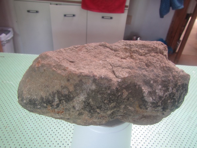
For this blog, I made a 3D-model of a tri-notched chipped and ground stone axe from the Gallina area (1100-1300 AD) in New Mexico using 3DF Zephyr Free.
The first try was a practice round to get the feeling for how to use the camera, what to do with the lighting, and whether it is better to rotate around the object or to rotate the object. I used my smartphone, a Huawei P8lite with a 13MP camera, to make the photos. Because of the object holding the axe, I wasn’t able to photograph its bottom.
Rough, sandstone tri-notched Gallina axe/hoe in process of being digitized at the camp house. Photo by Luke Oomen.
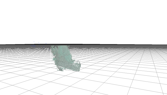
It took me five sets of photos in total to realize that the first try, the practice round, would be the only (semi) successful 3D-model. With two of the sets, one with my smartphone and one with the digital camera, I used the stationary object technique and circled around the axe. The second try did not have enough suitable pictures for the stone axe, but it accidentally did for a package of meat in the background. So first lesson learned: Get a clear background.
Program identifying pixels in the background package of meat. Image by Luke Oomen.
For another set, I used a cup to hold the axe and took 49 photos, however, the reflective surface of the cup distorted the images and the outcome was an unrecognizable model of the stone. Second lesson learned: don’t have reflective surfaces in your picture.
Pixels being captured from light reflected off of a coffee mug. Image by Luke Oomen.
I set up the tripod so the camera couldn’t move. I took a total of 121 photos, but I didn’t manage to get enough suitable photos for a decent 3D-model. Whether it was the lighting, the camera, the background or something else I don’t know exactly. Third lesson learned: there are a lot of factors to take into account!
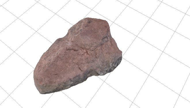
Static image of the final 3D model of the Gallina tri-notched (sometimes pol notched or bi-lobed) axe/hoe. Image by Luke Oomen
In the end I edited the result of the first try and I ended up with an incomplete but beautiful three dimensional model of the stone axe. This is the link to a YouTube video of the model: https://www.youtube.com/watch?v=gGjFw5wl6sc&t=18s.